Title: TIGER 2020 American Indian Lands
Originator: U.S. Department of Commerce, U.S. Census Bureau, Geography Division
Abstract:
The TIGER/Line Files are shapes and related database files that are an extract of selected geographic and cartographic information from the U.S. Census Bureau's Master Address File/Topologically Integrated Geographic Encoding and Referencing (MAF/TIGER) Database (MTDB). The MTDB represents a seamless national file with no overlaps or gaps between parts, however, each TIGER/Line File is designed to stand alone as an independent data set, or they can be combined to cover the entire nation.
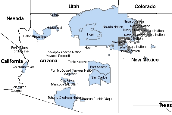
The American Indian / Alaska Native / Native Hawaiian (AIANNH) Areas Shapefile includes the following legal entities: federally recognized American Indian reservations and off-reservation trust land areas, State-recognized American Indian reservations, and Hawaiian home lands (HHLs). The statistical entities included are Alaska Native village statistical areas (ANVSAs), Oklahoma tribal statistical areas (OTSAs), tribal designated statistical areas (TDSAs), and State designated tribal statistical areas (SDTSAs). Joint use areas are also included in this shapefile and mean that the area is administered jointly and/or claimed by two or more American Indian tribes. The Census Bureau designates both legal and statistical joint use areas as unique geographic entities for the purpose of presenting statistical data. Note that tribal subdivisions and Alaska Native Regional Corporations (ANRCs) are additional types of American Indian / Alaska Native areas stored by the Census Bureau, but are displayed in separate shapefiles because of how they fall within the Census Bureau's geographic hierarchy.
The 2020 Census boundaries for federally recognized American Indian reservations and off-reservation trust lands are as of January 1, 2020, as reported by the federally recognized tribal governments through the Census Bureau's Boundary and Annexation Survey (BAS). The State of Hawaii's Office of Hawaiian Home Lands provided the legal boundaries used in Census 2000 for the HHLs, but provided no updates since and none for the 2020 Census although there is strong evidence of HHL land acquisitions and large housing and commercial development on most HHLs. The boundaries for ANVSAs, OTSAs, and TDSAs were delineated for the 2020 Census through the Tribal Statistical Areas Program (TSAP) by participants from the federally recognized tribal governments.
The Bureau of Indian Affairs (BIA) within the U.S. Department of the Interior (DOI) provides the list of federally recognized Tribes and only provides legal boundary information when the Tribes need supporting records, if a boundary is based on treaty or another document that is historical or open to legal interpretation, or when another Tribal, State, or local government challenges the depiction of a reservation or off-reservation trust land. The boundaries for State recognized American Indian reservations and for SDTSAs were delineated State governor appointed liaisons for the 2020 Census through the State American Indian Reservation Program and TSAP respectively.
The list of the 564 recognized sovereign tribal entities is located here.
Format: vector lines – ESRI Shape File
Spatial Reference Information: Decimal Degrees, North American Datum 1983