Title: National Elevation Dataset (NED)
Originator: U.S. Geological Survey (USGS), EROS Data Center
Abstract:
The U.S. Geological Survey has developed a National Elevation Database (NED).The NED is a seamless mosaic of best-available elevation data. The 7.5-minute elevation data for the conterminous United States are the primary initial source data. In addition to the availability of complete 7.5-minute data, efficient processing methods were developed to filter production artifacts in the existing data, convert to a consistent datum, edge-match, fill slivers of missing data at quadrangle seams, recast the data to a consistent geographic projection and convert all elevation values to decimal meters as a consistent unit of measure. The USGS Elevation site is located here. National Elevation Dataset Metadata and the data dictionary is located here.
One of the effects of the NED processing steps is a much-improved base of elevation data for calculating slope and hydrologic derivatives. Artifact removal greatly improves the quality of the slope, shaded-relief, and synthetic drainage information that can be derived from the elevation data. Geospatial elevation data are used by the scientific and resource management communities for global change research, hydrologic modeling, resource monitoring, mapping, and visualization applications.
NED has a resolution of one-third arc-second (approximately 10 meters) for much of the conterminous United States, Hawaii and Puerto Rico in a NAD83 datum. There is a resolution of two arc-seconds (approximately 60 meters) for Alaska and the datum is NAD27. The vertical datum for all areas, except Alaska, is NAVD88. Alaska is NAVD29.
The following products are available:
NED 3 (1/9 arc-second approximately 3 meters) This is the highest resolution available.
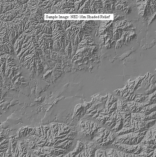
NED 10 (1/3 arc-second approximately 10 meters) NED at 10 meters is created using the same methods outlined above with the source data being mostly the 10m DEMs. DEMs at 5 meters, 1/3 arc-second, and 1/9 arc-second maps are also used where available. In some cases, the 10m NED is resampled from LIDAR or created using aerial photography.
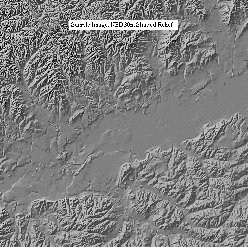
NED 30 (One arc-second approximately 3o meters) The 30 meter NED is ~1 arc-second data that is updated over large areas by integrating the 10 meter or better source data(where available), re-sampled to 1 arc-second. Where 10 meter or better is not available, 30 meter is used.
NED 60 (Two arc-second approximately 60 meters) There is a resolution of two arc-seconds (approximately 60 meters) for Alaska and the datum is NAD27. The vertical datum in Alaska is NAVD29.
NRCS has elected to serve maps in a UTM projection, in one degree or seven and one-half minute quadrangles and also mosaic areas of coverage into a single quadrangle when there are multiple project areas covering the quadrangle. These facts differentiate the maps from those served at USGS National Map Viewer.
The Gateway NED maps show the resampling property as Nearest Neighbor. Nearest Neighbor is the resampling method used to construct the pyramids, not the actual map data. Either bilinear interpolation or cubic convolution is recommended for continuous type elevation data to resample and reproject from the source geographic data to a UTM projection. The USGS uses bilinear interpolation, which determines the new value of a cell based on a weighted distance average of the four nearest input cell centers. The Gateway uses cubic convolution, which fits a smooth curve through the 16 nearest input cell centers. Even though it is a more computer intensive operation, cubic convolution produces a smoother surface and honors negative elevations such as those in Death Valley, CA.
The elevation units are meters. This is the same units as the map window and cell dimensions. The spatial metadata attributes of each source dataset, such as original resolution, production method, and dates, are in a polygonal shape file located at here.
Format: GeoTIFF
Spatial Reference Information: Universal Transverse Mercator, North American Datum 1983 (1927 for AK)