Title: IFSAR Elevation.
Originator: Intermap Inc. and NRCS
Abstract:
These maps are created from X-band InterFerometric Synthetic Aperture Radar (IFSAR) high-resolution digital elevation maps. The maps are proprietary and limited to Natural Resource Conservation Service (NRCS) and Farm Service Agency (FSA) personnel.
IFSAR operates day or night, in clear or cloudy conditions. The maps are developed by Intermap Inc., a global provider of high-accuracy, high-resolution digital elevation map products. The product handbook contains information on the products, applications, technology, how to load the maps into various GIS software packages and product licensing agreements.
The maps are GeoTiff format 7.5-minute by 7.5-minute units corresponding to
the USGS 1:24,000 scale topographic quadrangle map series for available areas
in the
There are four different geospatial datasets: Orthorectified
Radar Imagery (ORI), Digital Surface Models (DSM), and Digital Terrain Models
(DTM), and Correlation maps (COR).
|
|
|
|
|
|
ORI |
DSM |
DTM |
COR |
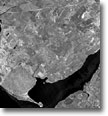
An Orthorectified Radar Image (ORI) is a grayscale image of the earth's surface that looks very similar to a monochromatic aerial photograph. However, ORIs are able to accentuate features far more than is possible with traditional aerial photography.
The nominal ORI data files are digital representations of the radar response signal. ORIs consist of a georeferenced pixel for a number of ground positions atwww. regularly spaced intervals. These ORI products represent the first reflective surface as illuminated by the radar. Diminished accuracies are to be expected in areas of extreme terrain and dense vegetation.
ORIs are at 1.25-meter pixel resolution orthorectified to a horizontal accuracy of 2.0 meters RMSE. Automated procedures are used to seam imagery passes, water is set to 1, void areas set to 0 and water is spread to tile edges. The ORI will be stretched to provide the optimum information content to the viewer.
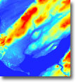
A Digital Surface Model (DSM) is a first surface view of the earth containing both location and elevation information created from pairs of ORIs. The ORIs and DSMs display the first surface on the ground that the radar strikes, including terrain features, buildings, power lines, and vegetation such as large trees or forests.
DSMs are 5-meter posted DEMs accurate to +/-1.0 meter (or better) vertical RMSE on slopes less than 25%, and 3.0 meters (or better) on slopes greater than 25%-35%. Beyond 35% the accuracy is expected to be 5 meters. The data is edited using semi-automated and manual procedures. Water is to be flattened/stepped, major valleys and major roads are smoothed.
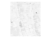
A Digital Terrain Model (DTM),
or "bald earth" as it is often referred, is created by digitally
removing all of the cultural features inherent to a DSM - exposing the
underlying terrain. DTMs are useful for applications
where an accurate sense of the underlying terrain is needed.
DTMs are 5-meter posted DEMs accurate to +/- 1.0 meter (or better) vertical RMSE. The DTM “bald earth” model references the elevation measurements of the bare terrain. Extensive hydrographic editing is guided by USGS quads for water flow. Water elevations are established and transferred from the DSM. Interstate, state and other major roads and ridges and valleys are edited. The DTM is understood to be influenced by the existence of continuous or extensive tree coverage, as described in the Intermap Product Handbook. The data is edited using Nextmap’s advanced semi-automated and manual procedures to remove small areas of trees and other artifacts such as transmission towers and agriculture and vegetative influences.
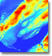
A Correlation Map (COR) is co-registered with the elevation models. This map represents the degree of correlation between the two radar signals received by the IFSAR system on a pixel by pixel basis. The higher the value, the closer the two signals agreed and therefore, the more confidence that can be placed on the accuracy of that pixel. In difficult terrains (steep slopes, dense urban areas, and areas of shadow), the signal may have such low correlation that the pixel in the DSM will be left blank in the interferometric processing phase and subsequently interpolated based on surrounding pixels. In the COR file, pixels that have been interpolated will be set to 0, while all remaining pixels will vary in value from 1 to 255, with the brightest pixels (255) having the best correlation. There are no horizontal nor vertical accuracies associated with this data set.
Purpose:
These data have been created as a result of the need for having geospatial data immediately available and easily accessible in order to enhance the capability of Federal, State, and local emergency responders, as well as plan for homeland security efforts.
These data are prepared for use by
the Natural Resources Conservation Service for
Format: All four types are GeoTiff.
Units: The units for DSM and DTM are meters. The units for COR and ORI are 0-255. The horizontal coordinates for all types are either geographic coordinates (latitude/longitude) with units of degrees or northings/eastings in meters.
Spatial Reference Information: Universal Transverse Mercator (UTM) or State Plane, NAD83 horizontal datum and NAVD88 (Geoid99) vertical datum.