Title: Alaska IFSAR Elevation.
Originator: USGS
Abstract: These maps are created from X-band InterFerometric Synthetic Aperture Radar (IFSAR) high-resolution digital elevation maps. The Alaska IFSAR project is being administered by the USGS, with major funding contributors including the National Geospatial-Intelligence Agency (NGA), State of Alaska, and USGS. Supporting contributors include the Natural Resources Conservation Service (NRCS), Bureau of Land Management (BLM), the National Park Service, the US Fish and Wildlife Service and the US Forest Service.
Alaska IFSAR is open to all users unlike IFSAR for the lower 48 and Hawaii which is restricted to NRCS and FSA.
These data, in 15-minute by 15-minute GeoTiff format, consists of three products: Bare-earth DEM (DTM), Surface DEM (DSM), and an orthorectified radar intensity image (ORI). The elevation models have a 5-meter post spacing, 22-foot contour equivalent accuracy, vertical accuracy of 3-meter LE90 (0-10 degree slope) and horizontal accuracy of 12.2-meter CE90*.
|
|
|
|
|
|
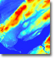
DTM |
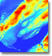
DSM |
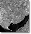
ORI |
All datasets have been processed and delivered in Alaska Albers Equal Area Conic (EPSG:3338), NAD83 horizontal datum and NAVD88 vertical datum. The data includes FGDC Metadata, hydrologic enforcement, quality masks, and no more than 3% of void fill.
The IFSAR data can also be downloaded from this site: http://ifsar.gina.alaska.edu/. Additionally, links to ArcGIS Online Layer Packages are available for the Alaska IFSAR Tile Index, DSM Hillshade, DTM Hillshade, and ORI. A Web Map Service is also available - http://wms.alaskamapped.org/ifsar?
Format: All three types are GeoTiff.
Units: The vertical units for DSM and DTM are meters. The units for ORI are 0-255. The horizontal coordinates for all types are northings/eastings in meters.
Spatial Reference Information: Alaska Albers Equal Area Conic (EPSG:3338), NAD83 horizontal datum and NAVD88 vertical datum.
* CE90, (Circular Error of 90%). CE90 is commonly used for quoting and
validating geodetic image registration accuracy. A CE90 value is the minimum
diameter of the horizontal circle that can be centered on all
photo-identifiable Ground Control Points (GCPs) and also contain 90% of their
respective twin counterparts acquired in an independent geodetic survey.
Approximate map scale equivalencies based on the US
NMAS
(United
States National Map Accuracy Standard)
|
Map Scale |
CE90 |
RMSE |
1-Sigma |
|
1:24000 |
12m |
6m |
3m |